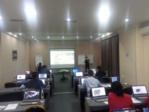
KyrgyzGeoTech LLC jointly with ISR Consult LLC has conducted training course on fundamentls of GIS by using Quantum GIS for professionals of the ministries and state instituions in September 22 – October 5, 2020 within the “Technology Based Adaptation to Climate Change in rural areas of Kyrgyzstan and Tajikistan” (TCCA-RA) project supported by the German Agency for International Cooperation (GIZ). The outline for 80 hours of theoretical and practical training and learning materials developed by taking into account professioanl activitiy and interest of participants. The set of video courses are prepared for self learning of GIS by using open sourse software QGIS, which are available here >>>.
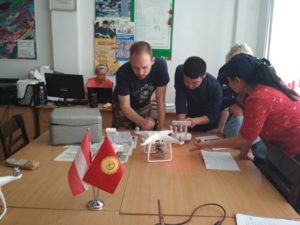
This training covers the fundamentals and principles of aerial imaging to enhance geodetic UAS operators’ knowledge in mapping with drones by understanding how to accurately plan and collate this imaging form various UAS platforms and digital sensing in order to produce and present enhanced geospatial products with photogrammetry and GIS applications.
The annual ‘GIS in Central Asia’ Conference – GISCA 2019 was successfully completed May 30-June 1 in Bishkek, Kyrgyzstan. GISCA 2019 was organized locally by the the Austria-Central Asia Centre for GIScience – ACA*GIScience at the Kyrgyz State University of Construction, Transport and Architecture (KSUCTA) with support from the Eurasia-Pacific Uninet, the Austrian Academy of Sciences’ Commission for GIScience and industry partners Trimble International, GeoTwo, Korea and KyrgyzGeoTech LLC.
About our company
Our company employs highly qualified certified professionals with extensive experience in the relevant fields of geodesy, geoinformation technology and construction. The company has appropriate equipment and infrastructure, licenses and uses modern electronic geodetic instruments, GPS receivers, computers and office equipment, software and civil engineering tools.
We pay great attention to cooperation with our customers and partners, as well as with state and private companies and institutions, taking into account their demands, the complexity of geodetic work, topographic and cadastral maps, GIS, plans of buildings, structures and tendering requirements. Employees and experts of the company have the required experience and potential to provide the final results of realized work with high quality and on time.
Our geodetic services can be divided into several groups and land survey is the main one. The result of the land survey is a topographic plan, which is covered with the most complete information about features of the territory – terrain, boundaries, green areas, buildings, communications or water bodies. Depending on the purposes the tacheometic or GPS surveys are performed in different scales, mainly in M 1:2000, 1:1000 and 1:500. Geodetic control or executive surveying helps to control the process of construction, reconstruction, and monitor the condition of the existing buildings. Its data can show geometric displacements of structures from the designed location, identify errors or detects the presence of deformations. Our surveyors create the geodetic survey networks on the construction site, calculate the volume of earth masses, set out building plans and perform qualitatively the entire complex of geodetic support for construction.

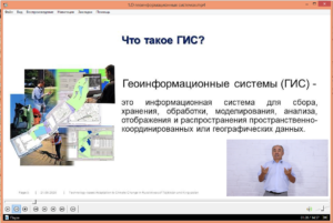
The Geoinformation Systems (GIS) are beginning to play an important role in different areas of the national economy today. GIS helps create a basic framework for collaboration and communication, providing a common field for linking data based on their spatial location. Our specialists design GIS with spatial datasets from the geodetic survey, GPS measurements and Remote Sensing.